New Terrain Map using USGS Topographical Map layer This release includes a new Terrain Map Layer for our MapBuilder tool. We have replaced the legacy Google Terrain Map with the USGS Topo Map. The Topo map provides better detail regarding the terrain of a site.
Release 11 04 0 Image1
Updated Resources Page and new API Change Log is being rolled out We have added new buttons for our API and SDK documentation, so that it is easier to get to this helpful documentation. If you have never visited our Resources page, you can get there by clicking the Resources link on the left hand navigation Bar:
Release 11 04 0 Image2
This will open the Resources Page, where you can find a link to our Release Notes, User Manual, Models and Algorithms documentation, API Documentation, Python SDK Documentation and Codebase. You can also find downloadable 3rd Party reviews and quick links to our Terms of Use and Legal Notices Page.
Release 11 04 0 Image3
Clicking on the Postman API Documentation, you can get to our API Changelog, which will contain important changes that are being rolled our to our API on a Release-by-Release basis. Some changes could be breaking changes to our customer’s API integrations, so we wanted to have an easy place of reference to find these changes. Here is a direct link to the Changelog: plantpredict-api
Release 11 04 0 Image4
Irradiance Optimization Default Values We have enhanced the Irradiance Optimization feature that we rolled out in Version 11.3.0, and applied default values as recommended by ourIrradiance Optimization documentation.
Release 11 04 0 Image5
We have also added these fields to our Company Level Defaults. If you have a Business, Pro or Enterprise Subscription, you can have a Company Admin who can set Company level default values
Release 11 04 0 Image6
MWDC and MWAC display order has been made more consistent through the application We had some inconsistency within our application regarding the order which the MWDC and MWAC were being displayed. We have standardized on MWDC on the left and MWAC on the right.
Release 11 04 0 Image7
Added a Unique Prediction ID to the Nodal Data Files and changed some column names and order to be more consistent with the User Interface When comparing Nodal Data results between 2 predictions, Excel would not let you open 2 files that have the same name. This resulted in an extra step of saving one file locally and renaming it before opening the second file. We have resolved this and added the PredictionID to the file names.
Release 11 04 0 Image8
Within the Array Nodal file, we updated the following columns:
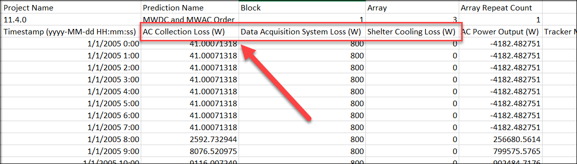
  • Rename “Total AC Power Loss” to “AC Collection Loss”
  • Move AC Collection Loss in line with UI representation (AC Collections, Data Acquisition, Cooling)
    • Rename Auxiliary Loss to Data Acquisition Loss
  • Move Cooling to the end to match the UI.
    Release 11 04 0 Image9
We added the Thermal Models to the Quick Edit Section of a Prediction When working with a Block Builder prediction, there is a “Quick Edit” screen that facilitates updating values across your DC Fields in a very easy manner. You can access the Quick Edit screen from the Blocks and arrays section of a Prediction as shown below:
Release 11 04 0 Image10
Once inside the Quick Edit screen, you click on the Display Fields drop down:
Release 11 04 0 Image11
And select the Thermal Model option:
Release 11 04 0 Image12
Release 11 04 0 Image13
Bug Fixes In addition to the above mentioned features and improvements, we also resolved the following Bugs:
  • Sandia Inverter Efficiency Model can’t handle when an inverter only has 1 efficiency curve. This has been fixed.
  • Predictions in the Southern Hemisphere now default to Azimuth = 0.
  • Predictions that were failing would appear to be stuck in a running state. We have fixed this so that a failure will report the failure to the user.
  • The “Generate API Credentials” link was not appearing on the Company Admin / User Profile page unless the admin refreshed the page. This has been fixed.
  • Post Height Validation has been converted to a warning instead of an error, so that sub-optimal post heights will no longer stop a prediction from running.
  • There was a limitation on weather file records of 525,600 records. We have removed this limitation.